
Those who don't regularly participate in these Q Anon threads have no appreciation of how thoroughly our adopted motto,
-- pervades our behavior here.
I recently experienced an exemplary negative demonstration here on FR, :
When Jeffrey Epstein was arrested, I took the occasion as an opportunity to share "out in the wilds of FR" some of the "OHI" (OverHeadImagery) work on Little St.James Island ("LSJI") we FReeQs have done here. Immediately, I encountered a discussion (in FR's "Can your conspiracy theory top this?" style) -- of the warped images of the LSJI "Tennis Court" found on Google Earth (aka "GE").
There was pontification that the Tennis Court was nothing more than a fake image, was the wrong shape, and, the painted lines were too sharp and clear for a satellite image!
Therefore, it definitely was a painted tarp on the ground, or a "tent" built to conceal all sorts of evils and, finally, that the tennis court was only a sort of "software mask" that Epstein had planted in GE to hide his perfidy...
Suffice it to say that my efforts to "set the record straight" were met with "anti-Q" FReeper derision -- so I retreated to this "WWG1WGA" refuge! '-)
I've long been convinced I have the correct -- if prosaic -- answer to the issue of "Warped Tennis Courts'". In fact, EMI_Guy recently reminded me that we had discussed the subject a year or so ago...
I've worked on and off on graphics to explain the phenomenon -- but the explanation hinged on the premise that the tennis court had been built on an "artificial plateau" where the top of a rounded peak had been cut down and spread out to form a large flat area.
Such "dirt work" would have occurred ca 2004 or 2005 -- but the GE database is empty or useless (cloud-obscured) over a gap from 2002 to 2006.
So -- without the key evidence of hill removal and flattening -- the subject of "Warped Tennis Court" was put "on hold"...
Then, the "WWG1WGA" principle came to my rescue! Without being asked, buffaloguy -- on his own initiative, used his phone to research in a database I didn't even know existed. Then, in true WWG1WGA fashion, buffaloguy shared this with me:
Post 362 has an URL for a satellite image (NOAA) of Little St. James Island. The initial image is from 2018 and on my phone if you use a spreading motion an older image comes up. It shows the leveling of the hill in preparation for the tennis court. Lots of dirt (not rock) was moved elsewhere. Many cubic yards were sliced off the top, loaded into trucks and dumped somewhere else. <SNIP>
I can’t see any date on the older map but it would be from between 1997 and 2003, a WAG.
366 posted on July 27, 2019 at 12:50:02 AM CDT by buffaloguy
So, quickly -- like diving down a rabbit hole, I followed buffaloguy's totally unsolicited instructions -- and, Voila! The Missing link! The Keystone!!!:

There it is: the rounded top of the hill -- being cut down! Now, we have a logical, contiguous sequence:

Google Earth simulates 3-d overhead images -- by "draping" the image over a digitized model of the earth's surface:


The pièce de résistance is this elevation plot -- using Google Earth's own "Elevation Profile" tool:
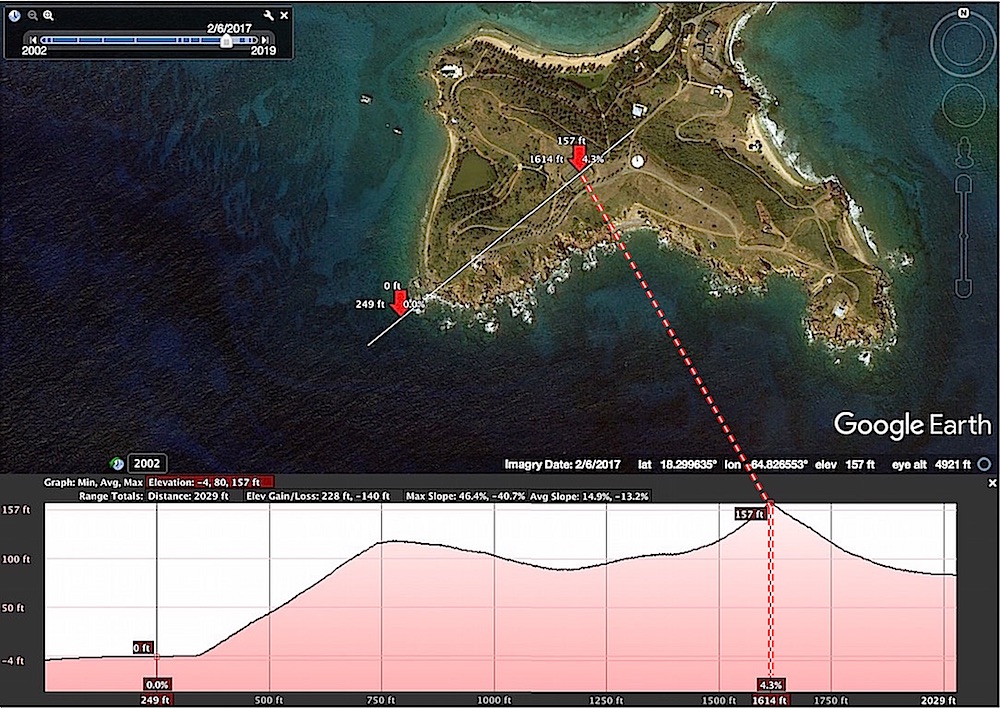
The elevation data is from Google Earth's "DSM -- which still "thinks" the highest point on the island (a sharp peak) is right in the middle of the Tennis Court!